 Milon Shil All About Entertainment, Lander World
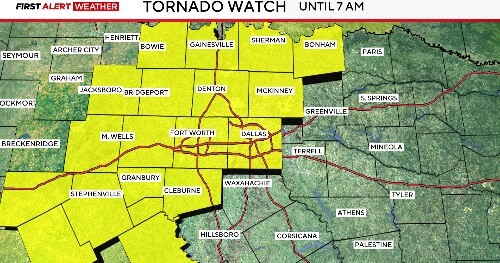 Residents across Texas are urged to stay vigilant as a severe weather system moves through the state, bringing threats of tornadoes, large hail, and powerful wind gusts. The National Weather Service (NWS) has issued a Tornado Watch for southern Texas and a Severe Thunderstorm Watch for northern regions, both in effect until 5 AM Sunday. This developing storm system could produce life-threatening conditions, including isolated tornadoes, hail up to 2 inches in diameter (baseball-sized), and wind gusts exceeding 70 MPH.
Key Threats and Affected Areas
The most dangerous conditions are expected in southern Texas, where rotating supercell thunderstorms may spawn strong tornadoes. Meanwhile, northern Texas faces risks of damaging straight-line winds and destructive hail.
Major cities at risk include:
- San Angelo (High tornado risk overnight)
- Abilene (Large hail threat—vehicles and property at risk)
- Ballinger & Sweetwater (Severe winds could cause power outages)
- Waco & Austin (Storms expected to push eastward by early Sunday)
Timing of the Severe Weather
- Saturday Night (10 PM – 3 AM): Storms intensify across West-Central Texas, with the highest tornado risk south of I-20.
- Early Sunday (3 AM – 7 AM): Eastern regions, including Dallas-Fort Worth, may experience strong winds and heavy rain.
Safety Tips to Protect Yourself
- If a Tornado Warning is Issued:
- Seek shelter in a windowless interior room or basement.
- Cover yourself with a mattress or heavy blankets for protection.
- During Severe Thunderstorms:
- Stay indoors away from windows to avoid flying debris.
- Unplug electronics to prevent damage from power surges.
- If Traveling:
- Avoid driving—flash flooding and hail can make roads hazardous.
- If caught outside, find a low-lying area and protect your head.
Why Is This Storm So Dangerous?
This severe weather outbreak is fueled by a strong cold front clashing with warm, moist air from the Gulf of Mexico. The Storm Prediction Center (SPC) has highlighted a 10% chance of strong (EF2+) tornadoes in the watch zone—a significant risk for overnight storms.
Final Safety Reminder
- Stay alert for weather alerts on your phone or NOAA Weather Radio.
- Prepare an emergency kit with water, flashlights, and a first-aid kit.
- Avoid downed power lines after the storm passes.
Conclusion:
Texas faces a high-risk overnight weather event, with southern regions most vulnerable to tornadoes. Residents must take warnings seriously and be ready to act quickly if conditions worsen. Stay updated with the latest forecasts from the NWS and local authorities for life-saving information.